
Hi. We've been using Clear for our K7LWH repeater IRLP service for a couple of years. But, Clear will be shutting down in November. I looked at the HamWAN coverage map for our site on Rose Hill, and it looks like the coverage is pretty marginal. It would be great if we could get some idea of what kind of coverage we'd have. Our repeater is here: 47.663872°, -122.166610° (just west of the water tower) Thanks. Don Sayler W7OXR Treasurer, Lake Washington Ham Club

Looks good on the computer! How high up the tower can you mount a dish? Does the water tower obscure the horizon? Tom KD7LXL On Tue, May 5, 2015 at 9:36 PM, Don Sayler <don.sayler@gmail.com> wrote:
Hi.
We've been using Clear for our K7LWH repeater IRLP service for a couple of years. But, Clear will be shutting down in November.
I looked at the HamWAN coverage map for our site on Rose Hill, and it looks like the coverage is pretty marginal. It would be great if we could get some idea of what kind of coverage we'd have.
Our repeater is here: 47.663872°, -122.166610° (just west of the water tower)
Thanks. Don Sayler W7OXR Treasurer, Lake Washington Ham Club
_______________________________________________ PSDR mailing list PSDR@hamwan.org http://mail.hamwan.net/mailman/listinfo/psdr
Hi Tom. Thanks for replying. I wasn't sure how to interpret the map. The red color is pretty pale over our location. Regarding the tower, I'd say we have the first 40 or 50 feet, the repeater antennas are above that. We don't have a climber, nor do we have the budget to hire an insured professional. Our site is on City of Kirkland property, so I'm sure they'd want all the i's dotted and t's crossed. Don On Tue, May 5, 2015 at 10:10 PM, Tom Hayward <tom@tomh.us> wrote:
Looks good on the computer! How high up the tower can you mount a dish? Does the water tower obscure the horizon?
Tom KD7LXL
On Tue, May 5, 2015 at 9:36 PM, Don Sayler <don.sayler@gmail.com> wrote:
Hi.
We've been using Clear for our K7LWH repeater IRLP service for a couple of years. But, Clear will be shutting down in November.
I looked at the HamWAN coverage map for our site on Rose Hill, and it looks like the coverage is pretty marginal. It would be great if we could get some idea of what kind of coverage we'd have.
Our repeater is here: 47.663872°, -122.166610° (just west of the water tower)
Thanks. Don Sayler W7OXR Treasurer, Lake Washington Ham Club
_______________________________________________ PSDR mailing list PSDR@hamwan.org http://mail.hamwan.net/mailman/listinfo/psdr
_______________________________________________ PSDR mailing list PSDR@hamwan.org http://mail.hamwan.net/mailman/listinfo/psdr
Oh, the water tower obscures the horizon to the east, but west is clear. And we probably have 70-80 feet available on the tower. On Tuesday, May 5, 2015, Tom Hayward <tom@tomh.us> wrote:
Looks good on the computer! How high up the tower can you mount a dish? Does the water tower obscure the horizon?
Tom KD7LXL
On Tue, May 5, 2015 at 9:36 PM, Don Sayler <don.sayler@gmail.com <javascript:_e(%7B%7D,'cvml','don.sayler@gmail.com');>> wrote:
Hi.
We've been using Clear for our K7LWH repeater IRLP service for a couple of years. But, Clear will be shutting down in November.
I looked at the HamWAN coverage map for our site on Rose Hill, and it looks like the coverage is pretty marginal. It would be great if we could get some idea of what kind of coverage we'd have.
Our repeater is here: 47.663872°, -122.166610° (just west of the water tower)
Thanks. Don Sayler W7OXR Treasurer, Lake Washington Ham Club
_______________________________________________ PSDR mailing list PSDR@hamwan.org <javascript:_e(%7B%7D,'cvml','PSDR@hamwan.org');> http://mail.hamwan.net/mailman/listinfo/psdr
On Wed, May 6, 2015 at 9:09 AM, Don Sayler <don.sayler@gmail.com> wrote:
Oh, the water tower obscures the horizon to the east, but west is clear. And we probably have 70-80 feet available on the tower.
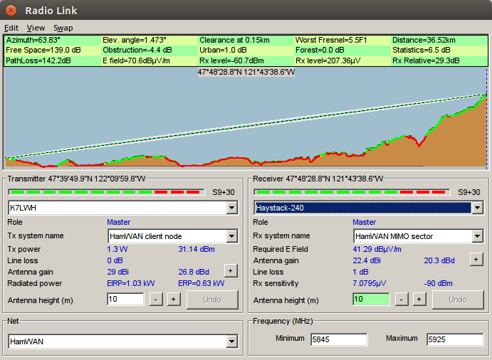
That's no good. Here's the link prediction from my last message plotted in Google Earth. Looks like the water tower blocks the shot to Haystack. Is that tower location correct? I've attached the .kml so you can see it in 3d. Snohomish County DEM (north) and Capitol Park (southwest) are also options. They're predicted at about -70 dBm. By the way, the coverage map is digital (coverage or no coverage). A red pixel indicates coverage better than -70 dBm. Anything less than that we don't plot. Any shading you're seeing is just how it's displayed--it's not indicating a different signal level. A signal level of -70 dBm will give you "full speed" on the network. The modem can maintain a connection down to about -88 dBm, but it won't be as fast. The map is conservative in that nothing between -70 and -88 dBm is plotted. Also keep in mind that the map doesn't know what trees or water towers exist around your property. (It does some primitive land cover adjustments, but I've found binoculars or Google Earth to be more accurate.) Tom
That's hard to see on my phone, so I'll look at it this afternoon when I get home. On Wednesday, May 6, 2015, Tom Hayward <tom@tomh.us> wrote:
On Wed, May 6, 2015 at 9:09 AM, Don Sayler <don.sayler@gmail.com <javascript:_e(%7B%7D,'cvml','don.sayler@gmail.com');>> wrote:
Oh, the water tower obscures the horizon to the east, but west is clear. And we probably have 70-80 feet available on the tower.
That's no good. Here's the link prediction from my last message plotted in Google Earth. Looks like the water tower blocks the shot to Haystack. Is that tower location correct?
I've attached the .kml so you can see it in 3d.
Snohomish County DEM (north) and Capitol Park (southwest) are also options. They're predicted at about -70 dBm.
By the way, the coverage map is digital (coverage or no coverage). A red pixel indicates coverage better than -70 dBm. Anything less than that we don't plot. Any shading you're seeing is just how it's displayed--it's not indicating a different signal level. A signal level of -70 dBm will give you "full speed" on the network. The modem can maintain a connection down to about -88 dBm, but it won't be as fast. The map is conservative in that nothing between -70 and -88 dBm is plotted. Also keep in mind that the map doesn't know what trees or water towers exist around your property. (It does some primitive land cover adjustments, but I've found binoculars or Google Earth to be more accurate.) Tom
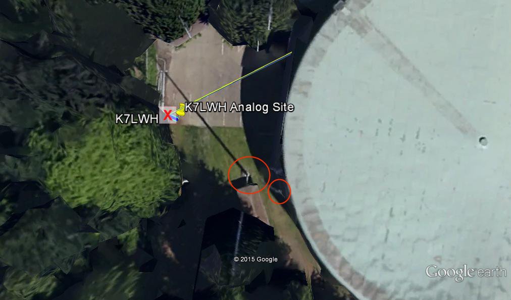
The black tower in the image is actually a shadow. In the attached image, I've circled the base of the tower and the top of the tower. The top of the mast clears the water tank, but I don't how much off the top of my head. And, there are a LOT of trees in the area. Our soon-to-be-gone Clear service is only 1.5 M, and that has been perfectly fine for IRLP and remote admin. On Wed, May 6, 2015 at 9:44 AM, Tom Hayward <tom@tomh.us> wrote:
On Wed, May 6, 2015 at 9:09 AM, Don Sayler <don.sayler@gmail.com> wrote:
Oh, the water tower obscures the horizon to the east, but west is clear. And we probably have 70-80 feet available on the tower.
That's no good. Here's the link prediction from my last message plotted in Google Earth. Looks like the water tower blocks the shot to Haystack. Is that tower location correct?
I've attached the .kml so you can see it in 3d.
Snohomish County DEM (north) and Capitol Park (southwest) are also options. They're predicted at about -70 dBm.
By the way, the coverage map is digital (coverage or no coverage). A red pixel indicates coverage better than -70 dBm. Anything less than that we don't plot. Any shading you're seeing is just how it's displayed--it's not indicating a different signal level. A signal level of -70 dBm will give you "full speed" on the network. The modem can maintain a connection down to about -88 dBm, but it won't be as fast. The map is conservative in that nothing between -70 and -88 dBm is plotted. Also keep in mind that the map doesn't know what trees or water towers exist around your property. (It does some primitive land cover adjustments, but I've found binoculars or Google Earth to be more accurate.) Tom
_______________________________________________ PSDR mailing list PSDR@hamwan.org http://mail.hamwan.net/mailman/listinfo/psdr
I'm having trouble understanding the details here. You say that the top of the mast clears the water tower. Does that imply you want to mount a HamWAN dish to the top of the mast, or is that just a point of reference? It's usually not practical to mount a dish to the top of a mast due to the high wind load of the dish. The critical detail is whether you can see the horizon from the level on the tower you want to mount the dish. Trees will likely block the signal, and the water tower will definitely block the signal. You mentioned that the City of Kirkland would want the i's dotted and the t's crossed. What does this mean specifically--what are you allowed to do on this tower? Tom On Wed, May 6, 2015 at 5:52 PM, Don Sayler <don.sayler@gmail.com> wrote:
The black tower in the image is actually a shadow. In the attached image, I've circled the base of the tower and the top of the tower. The top of the mast clears the water tank, but I don't how much off the top of my head. And, there are a LOT of trees in the area.
Our soon-to-be-gone Clear service is only 1.5 M, and that has been perfectly fine for IRLP and remote admin.
On Wed, May 6, 2015 at 9:44 AM, Tom Hayward <tom@tomh.us> wrote:
On Wed, May 6, 2015 at 9:09 AM, Don Sayler <don.sayler@gmail.com> wrote:
Oh, the water tower obscures the horizon to the east, but west is clear. And we probably have 70-80 feet available on the tower.
That's no good. Here's the link prediction from my last message plotted in Google Earth. Looks like the water tower blocks the shot to Haystack. Is that tower location correct?
I've attached the .kml so you can see it in 3d.
Snohomish County DEM (north) and Capitol Park (southwest) are also options. They're predicted at about -70 dBm.
By the way, the coverage map is digital (coverage or no coverage). A red pixel indicates coverage better than -70 dBm. Anything less than that we don't plot. Any shading you're seeing is just how it's displayed--it's not indicating a different signal level. A signal level of -70 dBm will give you "full speed" on the network. The modem can maintain a connection down to about -88 dBm, but it won't be as fast. The map is conservative in that nothing between -70 and -88 dBm is plotted. Also keep in mind that the map doesn't know what trees or water towers exist around your property. (It does some primitive land cover adjustments, but I've found binoculars or Google Earth to be more accurate.) Tom
_______________________________________________ PSDR mailing list PSDR@hamwan.org http://mail.hamwan.net/mailman/listinfo/psdr
_______________________________________________ PSDR mailing list PSDR@hamwan.org http://mail.hamwan.net/mailman/listinfo/psdr
Hi Tom. Sorry for the lack of clarity. My comment on the tower was for reference only. We have not had to do anything on the tower in a long time, so I'm not sure what we can and can't do. I'm going to look into that. I'm going to go up to the site this weekend and look at the height of the tank and the trees, and try to get some rough measurements. I know the tower is 120 feet. And it's certainly possible that hamWAN just won't work for us. Don On Thursday, May 7, 2015, Tom Hayward <tom@tomh.us> wrote:
I'm having trouble understanding the details here. You say that the top of the mast clears the water tower. Does that imply you want to mount a HamWAN dish to the top of the mast, or is that just a point of reference? It's usually not practical to mount a dish to the top of a mast due to the high wind load of the dish. The critical detail is whether you can see the horizon from the level on the tower you want to mount the dish. Trees will likely block the signal, and the water tower will definitely block the signal.
You mentioned that the City of Kirkland would want the i's dotted and the t's crossed. What does this mean specifically--what are you allowed to do on this tower?
Tom
On Wed, May 6, 2015 at 5:52 PM, Don Sayler <don.sayler@gmail.com <javascript:_e(%7B%7D,'cvml','don.sayler@gmail.com');>> wrote:
The black tower in the image is actually a shadow. In the attached image, I've circled the base of the tower and the top of the tower. The top of the mast clears the water tank, but I don't how much off the top of my head. And, there are a LOT of trees in the area.
Our soon-to-be-gone Clear service is only 1.5 M, and that has been perfectly fine for IRLP and remote admin.
On Wed, May 6, 2015 at 9:44 AM, Tom Hayward <tom@tomh.us <javascript:_e(%7B%7D,'cvml','tom@tomh.us');>> wrote:
On Wed, May 6, 2015 at 9:09 AM, Don Sayler <don.sayler@gmail.com <javascript:_e(%7B%7D,'cvml','don.sayler@gmail.com');>> wrote:
Oh, the water tower obscures the horizon to the east, but west is clear. And we probably have 70-80 feet available on the tower.
That's no good. Here's the link prediction from my last message plotted in Google Earth. Looks like the water tower blocks the shot to Haystack. Is that tower location correct?
I've attached the .kml so you can see it in 3d.
Snohomish County DEM (north) and Capitol Park (southwest) are also options. They're predicted at about -70 dBm.
By the way, the coverage map is digital (coverage or no coverage). A red pixel indicates coverage better than -70 dBm. Anything less than that we don't plot. Any shading you're seeing is just how it's displayed--it's not indicating a different signal level. A signal level of -70 dBm will give you "full speed" on the network. The modem can maintain a connection down to about -88 dBm, but it won't be as fast. The map is conservative in that nothing between -70 and -88 dBm is plotted. Also keep in mind that the map doesn't know what trees or water towers exist around your property. (It does some primitive land cover adjustments, but I've found binoculars or Google Earth to be more accurate.) Tom
_______________________________________________ PSDR mailing list PSDR@hamwan.org <javascript:_e(%7B%7D,'cvml','PSDR@hamwan.org');> http://mail.hamwan.net/mailman/listinfo/psdr
_______________________________________________ PSDR mailing list PSDR@hamwan.org <javascript:_e(%7B%7D,'cvml','PSDR@hamwan.org');> http://mail.hamwan.net/mailman/listinfo/psdr
participants (2)
-
 Don Sayler
 -
 Tom Hayward