2620 fire - potential impact to HamWAN operations

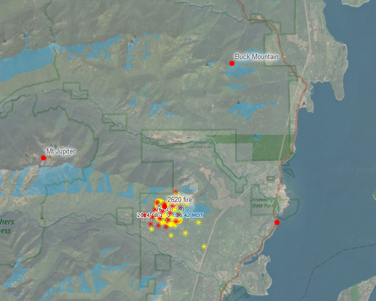
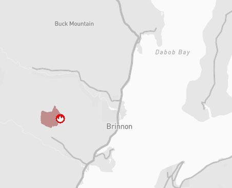
On Wednesday 8/14 a new fire started near Mt Jupiter on the Olympic peninsula near Brinnon, WA. In the last two days it has grown from 4 to ~350 acres. Details are still somewhat difficult to get as the fire is so new, but it's current position is about 5 miles south of the Buck Mountain site which serves a good bit of the Seattle area. At the moment the likelihood of getting that far is fairly low, but depends on how successful the containment efforts are. The forecast is a mixed blessing as rain is expected but is in the form of thundershowers Saturday into Sunday. Whether the rain helps or potential lightning and winds add to the problem is yet to be seen. The best info source I've found so far is https://datacentral.kitsapsun.com/fires/2620-road/2bb873f5-35fe-4791-9733-75 02a8f7e392/ Cheers, Rob

I swung the Cheryl St camera around and split the difference between Jupiter and Buck. http://stream.westin.hamwan.net/playersite_1b885dd6-2a6a-4351-bc9e-b081a2b9e... Currently the clouds and smoke are making visibility super poor. As the weather starts to draw and offshore breeze, this should get better. Jamie Hughes WA7JH (360) 340-8886 From: PSDR <psdr-bounces@hamwan.org> On Behalf Of rob@nr3o.com Sent: Friday, August 16, 2024 7:46 AM To: psdr@hamwan.org Subject: [HamWAN PSDR] 2620 fire - potential impact to HamWAN operations On Wednesday 8/14 a new fire started near Mt Jupiter on the Olympic peninsula near Brinnon, WA. In the last two days it has grown from 4 to ~350 acres. Details are still somewhat difficult to get as the fire is so new, but it's current position is about 5 miles south of the Buck Mountain site which serves a good bit of the Seattle area. At the moment the likelihood of getting that far is fairly low, but depends on how successful the containment efforts are. The forecast is a mixed blessing as rain is expected but is in the form of thundershowers Saturday into Sunday. Whether the rain helps or potential lightning and winds add to the problem is yet to be seen. [cid:image001.png@01DAEFB2.E2BA5390] [cid:image002.png@01DAEFB2.E2BA5390] The best info source I've found so far is https://datacentral.kitsapsun.com/fires/2620-road/2bb873f5-35fe-4791-9733-75... Cheers, Rob

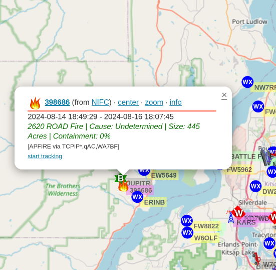
The fire icon on aprs.fi is informative: On 8/16/24 08:04, Jamie Hughes wrote:
I swung the Cheryl St camera around and split the difference between Jupiter and Buck.
http://stream.westin.hamwan.net/playersite_1b885dd6-2a6a-4351-bc9e-b081a2b9e...
Currently the clouds and smoke are making visibility super poor. As the weather starts to draw and offshore breeze, this should get better.
*Jamie Hughes*
WA7JH
(360) 340-8886
*From:*PSDR <psdr-bounces@hamwan.org> *On Behalf Of *rob@nr3o.com *Sent:* Friday, August 16, 2024 7:46 AM *To:* psdr@hamwan.org *Subject:* [HamWAN PSDR] 2620 fire - potential impact to HamWAN operations
On Wednesday 8/14 a new fire started near Mt Jupiter on the Olympic peninsula near Brinnon, WA. In the last two days it has grown from 4 to ~350 acres. Details are still somewhat difficult to get as the fire is so new, but it’s current position is about 5 miles south of the Buck Mountain site which serves a good bit of the Seattle area. At the moment the likelihood of getting that far is fairly low, but depends on how successful the containment efforts are. The forecast is a mixed blessing as rain is expected but is in the form of thundershowers Saturday into Sunday. Whether the rain helps or potential lightning and winds add to the problem is yet to be seen.
The best info source I’ve found so far is https://datacentral.kitsapsun.com/fires/2620-road/2bb873f5-35fe-4791-9733-75...
Cheers,
Rob
_______________________________________________ PSDR mailing list PSDR@hamwan.org https://mail01.fmt.hamwan.net/mailman/listinfo/psdr

Another data source about this fire: https://share.watchduty.org/i/30814 Overall map with all fires is here tho: https://app.watchduty.org/ --Bart On 8/16/2024 6:20 PM, Tony Ross via PSDR wrote:
The fire icon on aprs.fi is informative:
On 8/16/24 08:04, Jamie Hughes wrote:
I swung the Cheryl St camera around and split the difference between Jupiter and Buck.
http://stream.westin.hamwan.net/playersite_1b885dd6-2a6a-4351-bc9e-b081a2b9e...
Currently the clouds and smoke are making visibility super poor. As the weather starts to draw and offshore breeze, this should get better.
*Jamie Hughes*
WA7JH
(360) 340-8886
*From:*PSDR <psdr-bounces@hamwan.org> *On Behalf Of *rob@nr3o.com *Sent:* Friday, August 16, 2024 7:46 AM *To:* psdr@hamwan.org *Subject:* [HamWAN PSDR] 2620 fire - potential impact to HamWAN operations
On Wednesday 8/14 a new fire started near Mt Jupiter on the Olympic peninsula near Brinnon, WA. In the last two days it has grown from 4 to ~350 acres. Details are still somewhat difficult to get as the fire is so new, but it’s current position is about 5 miles south of the Buck Mountain site which serves a good bit of the Seattle area. At the moment the likelihood of getting that far is fairly low, but depends on how successful the containment efforts are. The forecast is a mixed blessing as rain is expected but is in the form of thundershowers Saturday into Sunday. Whether the rain helps or potential lightning and winds add to the problem is yet to be seen.
The best info source I’ve found so far is https://datacentral.kitsapsun.com/fires/2620-road/2bb873f5-35fe-4791-9733-75...
Cheers,
Rob
_______________________________________________ PSDR mailing list PSDR@hamwan.org https://mail01.fmt.hamwan.net/mailman/listinfo/psdr
_______________________________________________ PSDR mailing list PSDR@hamwan.org https://mail01.fmt.hamwan.net/mailman/listinfo/psdr

I generally use Inciweb. Note they mention radio tower protection as an objective. https://inciweb.wildfire.gov/incident-information/waolc-2620-road-fire Scott N7SS On Fri, Aug 16, 2024 at 7:02 PM Bart Kus <me@bartk.us> wrote:
Another data source about this fire:
https://share.watchduty.org/i/30814
Overall map with all fires is here tho:
--Bart
On 8/16/2024 6:20 PM, Tony Ross via PSDR wrote:
The fire icon on aprs.fi is informative:
On 8/16/24 08:04, Jamie Hughes wrote:
I swung the Cheryl St camera around and split the difference between Jupiter and Buck.
http://stream.westin.hamwan.net/playersite_1b885dd6-2a6a-4351-bc9e-b081a2b9e...
Currently the clouds and smoke are making visibility super poor. As the weather starts to draw and offshore breeze, this should get better.
*Jamie Hughes*
WA7JH
(360) 340-8886
*From:* PSDR <psdr-bounces@hamwan.org> <psdr-bounces@hamwan.org> *On Behalf Of *rob@nr3o.com *Sent:* Friday, August 16, 2024 7:46 AM *To:* psdr@hamwan.org *Subject:* [HamWAN PSDR] 2620 fire - potential impact to HamWAN operations
On Wednesday 8/14 a new fire started near Mt Jupiter on the Olympic peninsula near Brinnon, WA. In the last two days it has grown from 4 to ~350 acres. Details are still somewhat difficult to get as the fire is so new, but it’s current position is about 5 miles south of the Buck Mountain site which serves a good bit of the Seattle area. At the moment the likelihood of getting that far is fairly low, but depends on how successful the containment efforts are. The forecast is a mixed blessing as rain is expected but is in the form of thundershowers Saturday into Sunday. Whether the rain helps or potential lightning and winds add to the problem is yet to be seen.
The best info source I’ve found so far is https://datacentral.kitsapsun.com/fires/2620-road/2bb873f5-35fe-4791-9733-75...
Cheers,
Rob
_______________________________________________ PSDR mailing listPSDR@hamwan.orghttps://mail01.fmt.hamwan.net/mailman/listinfo/psdr
_______________________________________________ PSDR mailing listPSDR@hamwan.orghttps://mail01.fmt.hamwan.net/mailman/listinfo/psdr
_______________________________________________ PSDR mailing list PSDR@hamwan.org https://mail01.fmt.hamwan.net/mailman/listinfo/psdr
DNR aerial photo at https://thenwfireblog.com/2024/08/15/2620-road-fire-wa-august-15-2024/ On 8/16/24 19:08, Scott N7SS wrote:
I generally use Inciweb. Note they mention radio tower protection as an objective.
https://inciweb.wildfire.gov/incident-information/waolc-2620-road-fire
Scott N7SS
On Fri, Aug 16, 2024 at 7:02 PM Bart Kus <me@bartk.us> wrote:
Another data source about this fire:
https://share.watchduty.org/i/30814
Overall map with all fires is here tho:
--Bart
On 8/16/2024 6:20 PM, Tony Ross via PSDR wrote:
The fire icon on aprs.fi <http://aprs.fi> is informative:
On 8/16/24 08:04, Jamie Hughes wrote:
I swung the Cheryl St camera around and split the difference between Jupiter and Buck.
http://stream.westin.hamwan.net/playersite_1b885dd6-2a6a-4351-bc9e-b081a2b9e...
Currently the clouds and smoke are making visibility super poor. As the weather starts to draw and offshore breeze, this should get better.
*Jamie Hughes*
WA7JH
(360) 340-8886
*From:*PSDR <psdr-bounces@hamwan.org> <mailto:psdr-bounces@hamwan.org> *On Behalf Of *rob@nr3o.com *Sent:* Friday, August 16, 2024 7:46 AM *To:* psdr@hamwan.org *Subject:* [HamWAN PSDR] 2620 fire - potential impact to HamWAN operations
On Wednesday 8/14 a new fire started near Mt Jupiter on the Olympic peninsula near Brinnon, WA. In the last two days it has grown from 4 to ~350 acres. Details are still somewhat difficult to get as the fire is so new, but it’s current position is about 5 miles south of the Buck Mountain site which serves a good bit of the Seattle area. At the moment the likelihood of getting that far is fairly low, but depends on how successful the containment efforts are. The forecast is a mixed blessing as rain is expected but is in the form of thundershowers Saturday into Sunday. Whether the rain helps or potential lightning and winds add to the problem is yet to be seen.
The best info source I’ve found so far is https://datacentral.kitsapsun.com/fires/2620-road/2bb873f5-35fe-4791-9733-75...
Cheers,
Rob
_______________________________________________ PSDR mailing list PSDR@hamwan.org https://mail01.fmt.hamwan.net/mailman/listinfo/psdr
_______________________________________________ PSDR mailing list PSDR@hamwan.org https://mail01.fmt.hamwan.net/mailman/listinfo/psdr
_______________________________________________ PSDR mailing list PSDR@hamwan.org https://mail01.fmt.hamwan.net/mailman/listinfo/psdr
_______________________________________________ PSDR mailing list PSDR@hamwan.org https://mail01.fmt.hamwan.net/mailman/listinfo/psdr
Camera has been zoomed in. I’m trying to figure out how to get the playback option to work from overnight that shows the slow fire progression. Jamie Hughes WA7JH (360) 340-8886 From: PSDR <psdr-bounces@hamwan.org> On Behalf Of Tony Ross via PSDR Sent: Friday, August 16, 2024 8:23 PM To: psdr@hamwan.org Subject: Re: [HamWAN PSDR] 2620 fire - potential impact to HamWAN operations DNR aerial photo at https://thenwfireblogcom/2024/08/15/2620-road-fire-wa-august-15-2024/<https://thenwfireblog.com/2024/08/15/2620-road-fire-wa-august-15-2024/> On 8/16/24 19:08, Scott N7SS wrote: I generally use Inciweb. Note they mention radio tower protection as an objective. https://inciweb.wildfire.gov/incident-information/waolc-2620-road-fire Scott N7SS On Fri, Aug 16, 2024 at 7:02 PM Bart Kus <me@bartk.us<mailto:me@bartk.us>> wrote: Another data source about this fire: https://share.watchduty.org/i/30814 Overall map with all fires is here tho: https://app.watchduty.org/ --Bart On 8/16/2024 6:20 PM, Tony Ross via PSDR wrote: The fire icon on aprs.fi<http://aprs.fi/> is informative: [cid:image001.png@01DAF070.DAE11B40] On 8/16/24 08:04, Jamie Hughes wrote: I swung the Cheryl St camera around and split the difference between Jupiter and Buck. http://stream.westin.hamwan.net/playersite_1b885dd6-2a6a-4351-bc9e-b081a2b9e... Currently the clouds and smoke are making visibility super poor. As the weather starts to draw and offshore breeze, this should get better. Jamie Hughes WA7JH (360) 340-8886 From: PSDR <psdr-bounces@hamwan.org><mailto:psdr-bounces@hamwan.org> On Behalf Of rob@nr3o.com<mailto:rob@nr3o.com> Sent: Friday, August 16, 2024 7:46 AM To: psdr@hamwan.org<mailto:psdr@hamwan.org> Subject: [HamWAN PSDR] 2620 fire - potential impact to HamWAN operations On Wednesday 8/14 a new fire started near Mt Jupiter on the Olympic peninsula near Brinnon, WA. In the last two days it has grown from 4 to ~350 acres. Details are still somewhat difficult to get as the fire is so new, but it’s current position is about 5 miles south of the Buck Mountain site which serves a good bit of the Seattle area. At the moment the likelihood of getting that far is fairly low, but depends on how successful the containment efforts are. The forecast is a mixed blessing as rain is expected but is in the form of thundershowers Saturday into Sunday. Whether the rain helps or potential lightning and winds add to the problem is yet to be seen. [cid:image002.png@01DAF070.DAE11B40] [cid:image003.png@01DAF070.DAE11B40] The best info source I’ve found so far is https://datacentral.kitsapsun.com/fires/2620-road/2bb873f5-35fe-4791-9733-75... Cheers, Rob _______________________________________________ PSDR mailing list PSDR@hamwan.org<mailto:PSDR@hamwan.org> https://mail01.fmt.hamwan.net/mailman/listinfo/psdr _______________________________________________ PSDR mailing list PSDR@hamwan.org<mailto:PSDR@hamwan.org> https://mail01.fmt.hamwan.net/mailman/listinfo/psdr _______________________________________________ PSDR mailing list PSDR@hamwan.org<mailto:PSDR@hamwan.org> https://mail01.fmt.hamwan.net/mailman/listinfo/psdr _______________________________________________ PSDR mailing list PSDR@hamwan.org<mailto:PSDR@hamwan.org> https://mail01.fmt.hamwan.net/mailman/listinfo/psdr
That https://share.watchduty.org/i/30814g site is */very/* informative, Bart. A satellite time-sequence overlay is at https://zoom.earth/fires/us-wa-2620-road-fire/ Tony On 8/16/24 19:02, Bart Kus wrote:
Another data source about this fire:
https://share.watchduty.org/i/30814
Overall map with all fires is here tho:
--Bart
On 8/16/2024 6:20 PM, Tony Ross via PSDR wrote:
The fire icon on aprs.fi is informative:
On 8/16/24 08:04, Jamie Hughes wrote:
I swung the Cheryl St camera around and split the difference between Jupiter and Buck.
http://stream.westin.hamwan.net/playersite_1b885dd6-2a6a-4351-bc9e-b081a2b9e...
Currently the clouds and smoke are making visibility super poor. As the weather starts to draw and offshore breeze, this should get better.
*Jamie Hughes*
WA7JH
(360) 340-8886
*From:*PSDR <psdr-bounces@hamwan.org> *On Behalf Of *rob@nr3o.com *Sent:* Friday, August 16, 2024 7:46 AM *To:* psdr@hamwan.org *Subject:* [HamWAN PSDR] 2620 fire - potential impact to HamWAN operations
On Wednesday 8/14 a new fire started near Mt Jupiter on the Olympic peninsula near Brinnon, WA. In the last two days it has grown from 4 to ~350 acres. Details are still somewhat difficult to get as the fire is so new, but it’s current position is about 5 miles south of the Buck Mountain site which serves a good bit of the Seattle area At the moment the likelihood of getting that far is fairly low, but depends on how successful the containment efforts are. The forecast is a mixed blessing as rain is expected but is in the form of thundershowers Saturday into Sunday. Whether the rain helps or potential lightning and winds add to the problem is yet to be seen
The best info source I’ve found so far is https://datacentral.kitsapsun.com/fires/2620-road/2bb873f5-35fe-4791-9733-75...
Cheers,
Rob
_______________________________________________ PSDR mailing list PSDR@hamwan.org https://mail01.fmt.hamwan.net/mailman/listinfo/psdr
_______________________________________________ PSDR mailing list PSDR@hamwan.org https://mail01.fmt.hamwan.net/mailman/listinfo/psdr
participants (5)
-
 Bart Kus
 -
 Jamie Hughes
 -
 rob@nr3o.com
 -
 Scott N7SS
 -
 Tony Ross