Pacific County sites / planning - input needed

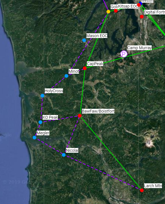
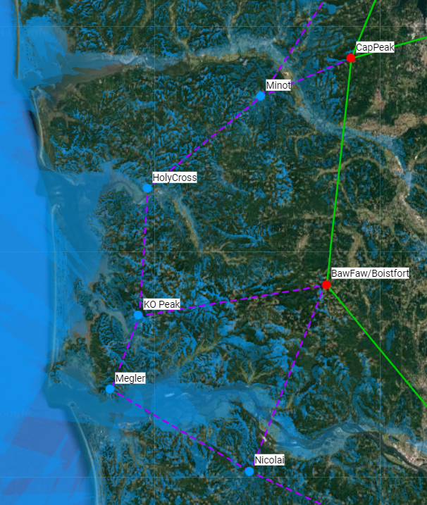
Greetings all, Been playing some catch-up as I get ready for MHDC this weekend and was working on some mapping. I laid out some potential routing based on the email chain that was going around. There are a couple of sites that I didn't see GPS coordinates for, so they are left off for the moment. These are Long Beach, North Cove, and Radar Ridge. If someone can get me coordinates for those I can add them to the map. Snapshots of the map are below. They show the primary sites I have coordinates for, and their (combined) expected coverage. Photo 1 (below) shows the basic routing being discussed. Photo 2 below shows the anticipated LOS coverage from these sites. Additional information (GPS coordinates and names) of the EOCs and/or other sites of interest to connect to the system can be placed on the map to show a first-draft of whether they are likely to be in a possibly covered area. Right now it was easier to show total coverage with the same color. Each site can be assigned a separate color to determine which (client) sites would be service by which (cell) sites. It is much easier to distinguish separate colors if the map is zoomed in and not covering such a wide area. Misc Notes: 1) BawFaw/Boistfort - I don't know the geography down there, but when I put the GPS coordinates for Boistfort in, it covered our existing BawFaw site exactly. If these are not in fact the same sites, I need better coordinates to get them split. 2) The URL for you to look at this map directly is: <https://caltopo.com/m/UT9N> https://caltopo.com/m/UT9N. The map is read-only, but you should be able to zoom in and move around. Information requested: 1) If there are additional sites to be considered to establish pathing (Long Beach, North Cove, and Radar Ridge, etc) let me know. I need site name and GPS coordinates (UTM preferred) 2) If you would like to see EOCs or other client sites shown on the map, I can do that as well. Need the same info as above. 3) If you want close-ups with coverage colors changed (example: KO peak as yellow and Megler as red), I can do that as well. Let me know what sites you want to see and I'll set it up. Zooming in with different colors would show for example which uplink site would best serve a given EOC / client site. For the moment I would like to consolidate all of the information so we can all be working off of the same map. I know there are some folks in Portland that this could be helpful to as well, and might bring secondary paths back into Pacific County from down there. Once the map is fairly static I have no problem duplicating it or dumping datasets for others to use. Give me a shout if you have any questions. You can also shoot me info off-list at rob@nr3o.com Cheers, Rob Salsgiver - NR3O
participants (1)
-
 Rob Salsgiver